WOLA’s Border Security and Migration team just returned from a trip along the southern border of Mexico. Over the course of two weeks, Senior Associates Adam Isacson and Maureen Meyer investigated the situation along Mexico’s southern border with Guatemala and what it means in the context of the U.S. immigration debate. The following are Adam Isacson’s daily blogs from the trip, which include photos, video, and commentary from the road. Check back soon for an upcoming report detailing their findings.
February 17, 2014
At WOLA we’ve done a lot of research and reporting about security and migration at the U.S.-Mexico border. But I haven’t been before to Mexico’s southern border with Guatemala, which is seeing a greatly increased flow of migration, and much else.
That’s where I’ll be for the next 12 days, starting tomorrow. I’ll be spending time in Mexico City plus all of the towns on the map above, crossing the border into Guatemala at least twice.
My plan is to report from the road as often as possible, and there will be a lot of travel time in which to do so. I look forward to posting about what we’re learning.
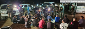
February 19, 2014
Tenosique, Mexico
Here’s where I was today: right in that odd corner-shaped border zone where Tabasco, Mexico meets Petén, Guatemala.
We’ve been pointing out that, as U.S. Border Patrol statistics confirm, we are witnessing a huge exodus from Central America. The number of Guatemalan, Salvadoran, and especially Honduran citizens trying to get to the United States has shot upward in the past three years or so.
The almost totally porous border zone near Tenosique, Tabasco is one of the early stages of that exodus. Tenosique lies at the beginning of one of the tracks for the trains that migrants ride northward, usually perched precariously on top.
Having already traveled through Guatemala’s sparsely populated Petén region, they cross this notional border and walk 35 miles along the main road to Tenosique and the trains. We saw dozens of them during two hours of driving.
Staff at migrant shelters in Tenosique and Palenque say that the population they are taking in is almost entirely Honduran—90 percent or more, even though we’re next to Guatemala, not Honduras. Many Honduran migrants say they have no choice but to leave because they have been threatened by maras, and the country’s collapsed security forces can’t, or won’t, protect them.
More later.
February 21, 2014
Villahermosa, Mexico
A few things I learned during two days along the northern part of the Mexico-Guatemala border:
- The vast majority of U.S.-bound migrants who cross the border here are from Honduras. Migrant shelter staff in both Tenosique and Palenque said that more than 90 percent of those showing up at their doors were Honduran, and all migrants with whom we spoke at the Tenosique shelter were Honduran. The other 10 percent or so, staff said, came mainly from Guatemala, El Salvador, Cuba (perhaps 10 per month) and occasionally from India.
- Hondurans choose this route because the bus ride across Guatemala’s Petén region is relatively fast. Citizens of Guatemala, Honduras, El Salvador, and Nicaragua don’t need visas in those four countries. When they reach the Mexico border, they have to go off the main paved road, to one of the innumerable unguarded crossings. Once in Mexico, they rejoin the paved road; most then walk the 35 miles to Tenosique. Migrants told us that the journey from Honduras to Tenosique took them four days. They do not take buses or public transportation inside Mexico because the migration authorities frequently board them. (I had to show my passport when our bus hit a checkpoint.) Migration personnel occasionally pursue migrants on these roads. I talked to some Honduran teenagers who had been chased the day before. They got away by hiding in the swamps by the side of the road.
- While they cannot take buses or drive, the migration authorities leave the cargo trains alone, for reasons I don’t yet understand. One of the northbound train lines begins in Tenosique, passing through Veracruz northward to the Mexico City area and on to U.S. border cities. Dozens of people ride on top of the train, which departs about once every eight days. While we were at the Tenosique shelter yesterday, a train whistle blew nearby. Everyone yelled “The train!” as they gathered up their knapsacks and ran for the exit. False alarm, though—it was a southbound train.
- Criminal gangs control access to the train. Some identified them as Central American maras extorting their fellow citizens. Before boarding, each migrant must pay gang collectors US$100, just to get to Coatzocoalcos, Veracruz. They will be charged US$100 for each subsequent leg of the trip. Those who board without paying are thrown off. The maras operate with no resistance from Mexican government or railroad authorities.
That’s it for now—our flight to Mexico City is boarding.
Tenosique, Mexico
Yesterday I accompanied Fray Tomás González, a terrific guy who runs the La 72 migrant shelter in Tenosique, Mexico, on a trip to see some unguarded crossings along the Mexico-Guatemala border. We drove until the pavement ended, then until the dirt road became rutted, then took a canoe through a brief flooded patch, then walked another mile. We ended up at a gate through a barbed-wire fence, with a small bullet-riddled sign posted by Mexico’s migration authorities. And I took this 100-second video.
February 22, 2014
Tultitlan, Mexico
“If we surprise you robbing or abusing people, we are going to lynch you,” warns a banner strung across a main street of the La Lechería neighborhood of Tultitlán, about half an hour north of Mexico City.
I spent this morning in La Lechería, an industrial suburb. This is the terminus of the train lines coming from the Guatemalan border hundreds of miles to the south. From here, the Central American migrants who have traveled atop the trains disembark and walk 20 miles north to the town of Huehuetoca, from where trains leave for four different points along the U.S. border.
As the sign shows, anti-immigrant sentiment is very strong in this community, which is already struggling economically. Residents have made very clear that Central American migrants aren’t welcome to stay here.
When volunteers have endeavored to set up shelters or soup kitchens to attend to arrivals, severe threats have forced them to yield. However, a few brave volunteers continue to bring food to the areas, mainly under highway viaducts, where migrants congregate.
February 23, 2014
Tapachula, Mexico
After 48 hours in Mexico City, we’re back along the Mexico-Guatemala border. While last week we visited the area around Tenosique, in Tabasco not far from the Gulf of Mexico, as of about two hours ago we’re in Tapachula, on the southern extremity of the border, not far from the Pacific. This is the state of Chiapas, across the border from Guatemala’s department of San Marcos.
Here, I’ve been joined by my colleague on WOLA’s border project, Maureen Meyer, WOLA’s senior associate for Mexico. Over the course of the week, we’ll be following a meandering route northward.
At first glance—and that’s all I’ve had—Tapachula looks like a shoppers’ paradise, with its own Wal-Mart and other chain stores, and a sizable mall on the outskirts, along the road in from the airport. But this municipality of about 300,000 people is also the busiest crossing along Mexico’s southern border. Unlike the sparse border zone I passed through last week (Tenosique was 35 rather empty miles from a very rural border), this area is densely populated. Cross-border flows are greater, and largely uncontrolled.
I’ll post more on Tapachula later, after I’ve talked to some of the local authorities, migrant shelter personnel, migrants, and civil-society groups. We’ll also be spending a couple of hours in Guatemala tomorrow, where we’ll visit a new army-police task force that has received U.S. support. I look forward to posting again after we’ve had many more conversations.
February 25, 2014
Tecún Umán, Guatemala
We wanted to see how easy it is to take one of the many inner-tube rafts available for hire across the shallow Suchiate River between Tecún Umán, Guatemala, and Ciudad Hidalgo, Mexico. It turns out to be very easy. This video documents the whole international trip, and it’s only three minutes long.
There is a bridge, with an official border crossing, about a quarter of a mile downstream from the rafts. But most people take the rafts: migrants, laborers, people with goods to sell, and no doubt people with less noble motives who’d rather avoid government entanglements.
And that’s easy to do, because we saw no presence of government authorities on either riverbank. They are only at the official crossing.
I apologize for some shaky camera work here, but I was standing on a raft.
This is the view from the back of a Guatemalan Army truck (U.S.-donated!), en route to a meeting yesterday near the Mexican border. We visited a forward operating base of “Tecún Umán”, a new border security task force that combines elements of Guatemala’s army, police, and customs.
Tecún Umán has been operational for six months. While its actual personnel strength is secret, it is roughly battalion-sized, and thus likely somewhere between 500 and 1,000 members. Its main area of responsibility is the southern part of Guatemala’s side of the common border, moving into the interior 30 or more miles, where one finds its main base in the city of Coatepeque, Quetzaltenango. However, the Task Force can be sent anywhere in the country.
“More or less everything you see here was paid for by the United States,” an Army official told us. The Tecún Umán Joint Task Force was prepared and equipped with funds from Defense Department counter-drug accounts. Annual foreign aid budget law has long prohibited (and now strongly conditions) aid to Guatemala’s army due to human rights concerns. These restrictions don’t apply, though, to the money that has gone to the Task Force’s facilities, training, and vehicles, because it’s in the defense budget, not the foreign aid budget.
The Defense Department supports Tecún Umán with anti-drug funds because
it is concerned about drug trafficking in this area, which sits astride the point where the Pan-American Highway crosses from Guatemala to Mexico. The nearby coastline, too, is a frequent landing site for illicit shipments, particularly of cocaine and methamphetamine precursors, while local ranches have private airstrips that could be misused. The area also suffers high levels of organized crime activity, extortion, and human trafficking.
The Task Force potentially represents a big new internal role for the Guatemalan military: public security in border zones. Officials are quick to point out that this is a joint unit combining both army and police personnel, and that when an operation involves policing work, the soldiers’ role is to support the police, who are out front and interacting with civilians. (Earlier in the day, we passed through a Joint Task Force roadblock. It had police personnel out front, and soldiers positioned conspicuously, but a few yards back along the roadside.)
It’s not clear yet how well this model works in practice, as Tecún Umán has only been operational since August. There have been few concrete results to report, while violent crime in this zone has been in a bit of a lull. Though migrants continue to stream across the border, interdicting them is not a mission for the task force—it may detain them, however, if it finds any during an operation. It’s not clear how often this happens.
Though Tecún Umán still gets a lot of U.S. training, most U.S. aid to the unit has been drawn down after the initial setup. Maintaining vehicles and equipment, paying for gas and supplies, and similar services are now mostly funded through Guatemala’s treasury.
But the unit’s facilities still have a very American feel, as they were built by Salvadoran contractors according to a Southern Command-provided design. The exit signs even say “EXIT” instead of “SALIDA.” In the cafeteria, an official noted the odd American design, with the kitchen separated from the dining room.
Defense Department military and police aid continues, meanwhile, as the Joint Task Force model expands in Guatemala. By the second half of this year, expect the launch of JTF Chortí, which will operate along the country’s border with Honduras.
Talisman, Mexico
Mexican soldiers interviewing bus passengers (including me) at two Army checkpoints along the Pacific coastal highway in Chiapas.
There are numerous checkpoints, of varying rigor, along this road between the Guatemalan border and the rest of Mexico. In addition to Army, we’ve been through federal and state police, customs, immigration (3 times so far), and the PGR (attorney-general’s judicial police). Not sure why they need to do them all separately. Does duplication of efforts deter drug traffickers?
February 26, 2014
Arriaga, Chiapas
Outside the migrant shelter in Arriaga, Chiapas. (From left: Carlos Bartolo Solís of the Casa de Migrante, Maureen Meyer of WOLA, migration expert Gabriela Morales, and me.)
The train from the Guatemalan border in Tapachula has been out of commission since a 2005 hurricane. Today, the line starts here in Arriaga, up the Pacific Coast not far from Oaxaca. Migrants make their way here—often walking for 15 days from the border, to avoid all those road checkpoints in yesterday’s post—and then board the train to La Lechería north of Mexico City (see post from February 21).
Right now the train has suffered a derailment, and there are no departures, and no clear sense of when they’ll start again. The Arriaga migrant shelter is totally full (capacity: 100) and turning people away.
February 27, 2014
San Cristóbal de las Casas, Mexico
We left the Pacific coastal highway zone and spent yesterday afternoon and evening in San Cristóbal de las Casas, a touristy and picturesque colonial city in the heart of Chiapas. This is where most of the state’s human rights groups are concentrated.
We had a 3 1/2-hour discussion with many of them. The activists highlighted numerous local concerns, some of them quite alarming.
- Large amounts of drugs, principally heroin and cocaine, crossing borders on land, by sea, and at airstrips, and passing northward via the road network.
- Northbound migrants from Central America, mostly Honduras—those who don’t take the train—being assaulted by criminals, and blackmailed by security and migration personnel who threaten them with deportation if they don’t pay up.
- Migrants who can pay smugglers’ steep fees encountering far fewer obstacles from officials on the region’s roads.
- Human trafficking networks forcing Central American women and girls to work as prostitutes in bars.
- Security forces at all levels doing little or nothing about all of this, due to corruption or even direct involvement.
- We heard very strong criticism of a “culture of abuse” within a
ll federal and state security forces. Arbitrary detentions, torture, and denials of due process are viewed as routine and almost never punished. - A sense that, where drug interdiction and migration control are concerned, Mexican forces are doing the bare minimum of what the U.S. government asks of them, in order to keep receiving things like facilities, vehicles, training, and especially intelligence.
- Accelerating land concentration as buyers use dishonest practices like high-interest loans to dispossess small landholders.
- Speculation that much of the land concentration owes to big plans for “megaprojects” in mining, energy (hydroelectric and palm-oil biofuels), and ecotourism.
- The region is also rife with rumors of assailants “in a white pickup truck” kidnapping children, killing them and selling their organs. Most activists doubted these rumors and speculated that they were part of an effort to make the population feel less secure, and thus more likely to welcome a greater security force presence in a state that has some of Mexico’s lowest levels of violent crime.
It was a rather grim discussion in a very pretty town. Now we’re headed back down to the Guatemala border.
The state of Chiapas, Mexico, is blanketed with billboards and signs promoting its young, well-connected governor, Manuel Velasco. Similar announcements visible in local and Mexico City media, and on social media, repeatedly tout purported results (roads built, health and education provided, police patrols, etcetera.)
These much-heralded results only date back to January 2013, when Governor Velasco was inaugurated. But the communications blitz makes clear that Velasco really wants to succeed President Enrique Peña Nieto after Mexico’s 2018 presidential elections.
Velasco and Peña Nieto have a lot in common. They are from the same political coalition, with the ruling PRI party’s machinery strongly behind them. They both began their current terms at the same time. Peña Nieto also rose to national prominence as a governor. Both are telegenic and young (Velasco, born in 1980, is very young). Peña Nieto is married to a soap opera star; Velasco is engaged to one.
To an outsider, the barrage of pro-Velasco publicity seems unseemly and old-school populist. But that doesn’t mean it won’t work. Manuel Velasco is clearly being groomed, and we’re likely to hear more from him.
Ciudad Cuauhtémoc, Mexico
A vehicle-mounted machine gun, earlier today on the Mexican side of the border crossing between Ciudad Cuauhtémoc, Mexico and La Mesilla, Guatemala.
February 28, 2014
Comitán, Chiapas
Our route for the next 12 or more hours. Leaving Comitán, Chiapas, where I’ve spent the night, and driving the highway that follows the Mexico-Guatemala border all the way back to where this whole trip started more than a week ago. We’ll arrive in Villahermosa sometime tonight. Then Saturday morning we fly back home.
This great trip is almost over. I’ll post photos and/or observations whenever cellular service exists.
Villahermosa, Mexico
It’s March now, and my 12 days in Mexico, mainly the Mexico-Guatemala border zone, end today. By April, WOLA will publish a big report about what we saw and learned. This will include some of the photos, videos, and observations I’ve made here over the past week and a half—but presented in a more orderly, rigorous fashion than I have done here. In the meantime, though, here are some more random impressions.
We spent Thursday and Friday in the south-central and southeastern parts of Chiapas. Here, Mexico’s southernmost state borders the Guatemalan departments of Huehuetenango, Quiché, Alta Verapaz, and Petén. These were some of the zones hardest hit by that country’s 1960-1996 civil war.
This is an area of rugged mountains, with lowland jungles that are being converted, as quickly as possible, into cattle pastures and oil palm plantations. There are numerous indigenous communities where, as in the Guatemalan highlands, residents wear traditional dress, speak Mayan dialects, and practice subsistence agriculture. In the south-central zone, where the border is a straight east-west line, there are several communities founded since the 1990s, on what had been large ranches until the Zapatista rebellion forced their owners to abandon them. The Mexican government’s response to the rebellion included a lot of road construction, and it is relatively easy to get around.
We saw evidence of wealth whose origin was unclear, in areas where large amounts of U.S.-bound drugs are believed to be crossing the border. Though there is little out-of-state tourism and scant evidence of mechanized agriculture in the surrounding countryside, the border-zone town of Comitán has gleaming shopping malls, car dealerships, boutiques, gourmet restaurants, and a pristinely restored town square devoid of panhandlers and sidewalk vendors—far from what comes to mind when one imagines “Chiapas,” Mexico’s poorest state. In the hardscrabble border town of Comalapa, we saw several late-model SUVs and trucks, many without license plates, being driven by young men.
If these signs of economic health are legitimate, then they are welcome. But experience in Colombia and elsewhere makes our antennae go up when there is no evidence of a booming industry, natural resource, or agricultural product in the surrounding area. When striking up conversations with waiters, cab drivers, and fellow bus riders, we heard no good answer when we asked about the region’s pockets of prosperity. This looks like narco money.
Immigration and security facilities exist at all border crossings, but these can be avoided with ease. Instead, authorities devote more effort to scrutinizing road traffic several miles to the north, at checkpoints and at customs facilities. There are to be three of these latter facilities, located at important crossroads or bottlenecks, through which all traffic must pass and (at least in the case of our bus) have their bags taken out and inspected. The customs complex in Huixtla, along the Pacific coastal highway, has been built, and appeared to have Army and police detachments co-located on site. While running my bags through the x-ray machine, I asked a customs official, “Is all this from Mérida?” (The “Mérida Initiative” is the name given to the framework through which about US$2 billion in U.S. aid has flowed since 2008.) He smiled and answered enthusiastically in the affirmative. Similar facilities are under construction in Palenque, in northeastern Chiapas, and in La Trinitaria, in south-central Chiapas.
Between the border and these checkpoints, there are few official controls. Citizens can easily come and go, whether to work or to buy and sell. Many Central American “migrants” in this zone—including those who show up in official government statistics of migrant detentions—in fact have no intention of coming to the United States. They seek to remain in Mexico’s border area, buying, selling, or seeking work. (Mexican citizens rarely deign to do seasonal work harvesting mangos and other crops, local migration experts told us in Tapachula.)
We saw a wide variety of checkpoints and revisions, but in almost no case did we see security agencies working together—with the exception of one roadblock jointly manned by the Federal Police and the National Migration Institute. Instead, there would be personnel from just one: here and along the Pacific coastal highway, we separately encountered Army, Navy, Migration Institute, Federal Police, Ministerial Federal Police, Attorney-General’s Office, Customs, State Police, and State Attorney-General’s Office. In the remote southeastern zone, all checkpoints are military. Distrust between agencies is a likely reason for the separation and dispersion between so many security bodies with overlapping responsibilities.
The checkpoints are far from foolproof. Most passenger vehicles are waved through or asked perfunctory questions. Several activists, experts, and citizens coincided in speculatinng that authorities seem more intent on detecting Central American migrants than criminal activity. Reports of corruption were rife. At none of the border checkpoints was there evidence of canine units, on which U.S. authorities rely to find large quantities of drugs.
In general, as we traveled the roads that closely follow the border, things appeared calm. Unlike Mexico’s northern border, levels of violence aren’t high here. But this doesn’t mean that everything happening here is legal. And especially in border towns that see few North Americans, some strangers asked us a few too many prying questions about the reasons for our visit.
I started writing this in the Villahermosa airport but am actually in the Mexico City airport now. This concludes my posting from the road. I’m going to northwestern Colombia during the second half of March, and look forward to doing it again then.